New and Improved Observations (NIO)
With the advent of satellite observations of the Earth for the purposes of weather studies starting in the 1960s, a new era began, focused on exploiting the capability to observe, track, and predict atmospheric phenomena on a global scale for the first time. Since the 60s, satellite data has progressively become the predominant source of information utilized by modern data assimilation systems. These are the systems that provide initial conditions for National Weather Predictions (NWP) models.
NWP models are capable of making optimal weather predictions through their use of satellite observations (radiances, imagery, signal phase/amplitude, etc.) as virtual measurements of the geophysical variables of interest and their physical relationships created by the process of data assimilation.
The NIO team works towards advancing up-and-coming research in satellite data assimilation and including improved satellite observations in their operations. The project aims to develop a strong data assimilation methodology and to enhance the sensor-specific readiness of satellites.
Recently, the JCSDA played a part in supporting the implementation of operational assimilation of COSMIC-2 data. The implementation of COSMIC-2 assimilation is the result of close collaboration between JCSDA and its partners at NOAA (NCEP, NESDIS, OAR), as well as with UCAR collaborators.
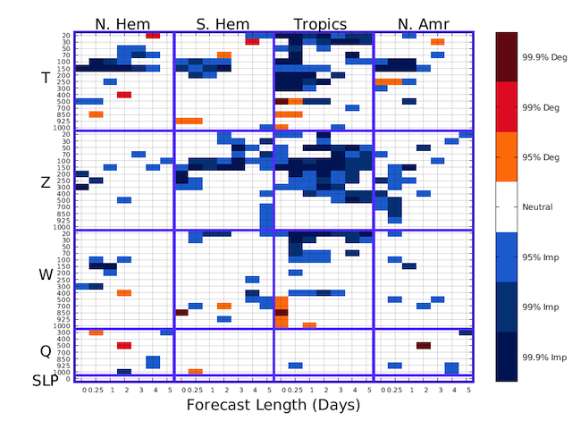
The improvement (Imp; blue) or degradation (Deg; red) of the forecast root-mean-square error (RMSE) against radiosonde observations data due to addition of COSMIC2 bending angles to the set of assimilated observations. Results are presented for the indicated variables (Q,W, Z, T, and SLP) and geographic categories at various pressure levels for forecast lengths out to five (5) days.
All-Sky Radiance Assimilation
This part of the data assimilation methodology focuses on improving the capabilities of current and planned data assimilation systems to ingest and assimilate satellite radiances under all atmospheric conditions (clear-sky, aerosols, clouds, precipitation). All-sky radiance research depends on the development of other projects; this work relies on specific improvements in the assimilation system itself (JEDI) and the forward modeling of radiances (UFO, CRTM).
Enhancing Existing Capabilities
The NIO team is working on actively tracking and responding to changes in the assimilation impact of any sensor/data-related changes, as well as providing specific technical and scientific guidance towards improving existing assimilation capabilities of sensors.
All-Surface Radiance Assimilation
All-surface assimilation focuses on the surface impacts of observed radiances and research regarding improvements in the characterization of surface emissivity in both weather model and radiative transfer domains. This research is made possible through programs such as the Community Surface Emissivity Model (CSEM) and direct coordination between physical modelers (Land Information Systems) and remote sensing scientists. The ultimate goal of all-surface assimilation is equivalent radiance assimilation over all surface types.
New Sensor Planning
Coordination with satellite instrument, data calibration, and validation teams, as well as operational partners, helps the NIO team to convert diverse expertise into innovative ideas and improved capabilities for the assimilation of new sensors.