
JCSDA Projects
Project research is done with proposal-based funds (internal research) as well as with external grants and contracts awarded via a competitive process open to the broader scientific community (external research).
There are also core projects that are not subject to the competitive process, but are regulated by an on-going agreement between the funding agency and the project principal investigators (directed research).
In addition, the JCSDA partners conduct their own internal projects and some of them are directly related to the JCSDA activities. These projects are labeled in-kind research projects.
The JCSDA supports scientific development work in several priority areas:
Radiative Transfer · Clouds and Precipitation · Advanced Instruments · Land Data Assimilation · Ocean Data Assimilation · Air Composition

Joint effort for data assimilation integration (JEDI)
JEDI scientists and software engineers work to provide a unified data assimilation framework for research and operational use — for different components of the Earth system and various applications. This project’s main objective is to reduce or avoid redundant work within the community, increase the efficiency of research, and assist in the transition from development teams to actual operation.
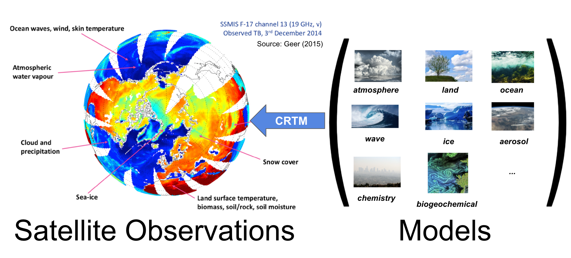
Community Radiative Transfer Model (CRTM)
CRTM is a fast and accurate radiative transfer model developed at the Joint Center for Satellite Data Assimilation (JCSDA) in the United States. It is a sensor-based radiative transfer model and supports more than 100 sensors, including sensors on most meteorological satellites and some from other remote sensing satellites.

New and Improved observations (NIO)
The NIO project works to advance state-of-the-art research in satellite data assimilation and prepare for the inclusion of new and improved satellite observations in a timely manner. The overarching goal of this project takes into account several elements that connect the fields of environmental science, numerical prediction, and satellite remote sensing.
Impact of observing systems (IOS)
IOS focuses on providing JCSDA partner agencies with an Observing System Experiment (OSE) infrastructure to evaluate lost satellites or data in a timely manner, Forecast Sensitivity to Observation Impact (FSIO) diagnostic tools, and automated, adaptive algorithms for processing satellite observations. All three of these goals are intended to optimize satellite performance and forecasts.

Sea-ice ocean and coupled Assimilation (SOCA)
The SOCA team works to merge atmospheric and marine data assimilation efforts for the design of both weakly coupled, and strongly coupled, data assimilation systems.